A school closure in Alberni will force school catchment area boundaries to be re-draw, school officials said.
The scenarios discussed so far involve closing Gill or Wood Elementary Schools.
A domino effect would ensue that would see Gill students absorbed into Alberni Elementary School. Some Alberni kids would be absorbed into John Howitt.
French Immersion students at Alberni would be moved to Maquinna Elementary, some students from which would be moved to Eighth Avenue Elementary.
Closing Wood Elementary School, and fanning students out to Alberni, Eighth Avenue and Maquinna has also been discussed.
In this scenario, VAST would cease operation at its current location and be moved into Wood. It is the district’s preference that VAST move into an existing school property. The district has said publicly that Wood is part of this scenario and have not publicly spoken about any other possible location.
Regardless of the scenario, boundaries will have to be re-drawn, officials have said.
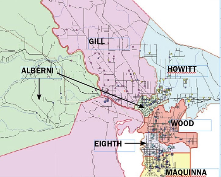
Below are the catchment areas as outlined in the School District 70 Policy and Procedures Manual:
Alberni Elementary: K-5 pupils residing in the area from Somass River, east on Roger Street to Gertrude, north on Gertrude Street to Rogers Creek, east on Rogers Creek to the intersection of the extension of Cherry Creek Road, north on Cherry Creek Road to Johnston Road, west on the south side of Johnston Road to Ian Avenue, north on Ian Avenue but not including Ian Avenue to Compton Road and Kitsuksis Creek, following Kitsuksis Creek south to the intersection of Alexander, west on Alexander, south on Heath to the Somass River to the origin of the area at Roger Street and the Somass River, and including areas south of the Somass River west of McCoy Lake Road.
◆ Alberni Elementary Capacity: 482 Enrollment: 313: 119 Eng.194 Fr. Spots available: 163
Wood School: K-5 pupils residing north from Third Avenue and Redford Street, east on Redford Street to Tenth Avenue, then south on Tenth Avenue to Dry Creek, then to the north of Dry Creek to Rogers Creek, except Roger Street from Gertrude Street to Victoria Quay.
◆ Wood School: Capacity: 214 Enrolment: 147 Spots avail: 62
Gill School: K-5 pupils residing north from Alexander and along the west side of Kitsuksis Creek to Best Road, then north on Kitsuksis Road including the Beaver Creek area to the Somass River on the west down to Heath Road; and including Mission Road area.
◆ Gill School: Capacity: 256 Enrolment: 211 Spots avail: 35
John Howitt: K-5 pupils residing on the west from Elkford Road on the Port Alberni Highway to Rogers Creek to the extension of Cherry Creek Road, then south side of Johnston west to Ian; north on Ian to Compton then following Kitsuksis Creek north to Best Road; west on Best to Kitsuksis Road, then north to Batty Road; east on Batty encompassing Cherry Creek area to Elkford Road.
Maquinna: K-5 pupils residing south-east of the line formed by following China Creek Road west from Carmichael Drive to Anderson, south on Anderson to Montrose, west on Montrose to Tenth Avenue, west on South Crescent to Sixth Avenue and west on Montrose to First Avenue to Alberni Inlet.
◆ Maquinna: Capacity: 392 Enrolment: 237 Spots avail: 147
Eighth Avenue: K-5 pupils residing from the Alberni Inlet on a line east to Montrose, South Crescent; north on Anderson, east on China Creek Road; then north to Dry Creek and west to Tenth Avenue; north on Tenth to Redford Street and west on Redford to the Alberni Inlet.
◆ Eighth Avenue: Capacity: 196 Enrolment: 154 Spots avail: 42
reporter@albernivalleynews.com
Twitter.com/AlberniNews