Edited: To reflect La Nina is associated with below-average temperatures, not above-average as originally stated.
BY MIKE YOUDS
Special to the News
This winter has been extra wet — an observation backed by rainfall records — yet it’s the irregular weather patterns that continue to stand out, a troubling trend in the face of climate change.
Environment Canada statistics in recent months support the observation that it’s been wetter than the average Alberni Valley fall and winter.
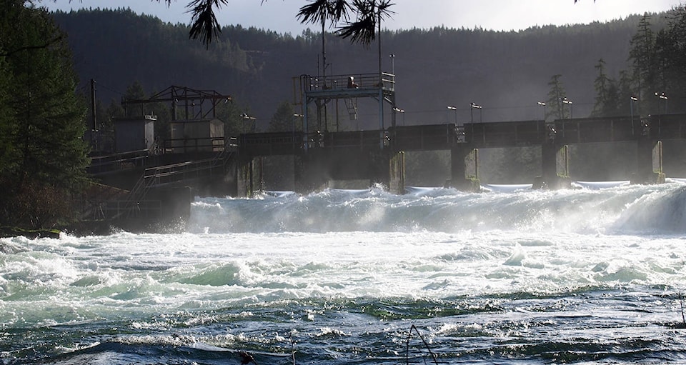
While December’s precipitation was significantly less than usual, both November and January brought more than average rainfall, swelling reservoirs and rivers.
November’s rainfall at the airport measured 489 mm compared with the average of 369, said Lisa West, an Environment Canada meteorologist. That’s 120 mm more than usual. December was markedly different thanks to a high-pressure ridge that protected southern B.C., bringing 84.2 mm of rain compared with the average of 318 mm.
“I’m not surprised December was way below weather normal,” West said.
January made up for it: 396 mm compared with the average 340. About one-fifth of that fell during a two-day storm at month’s end, totalling 71.9 mm. That front contributed to a doubling of the snowpack on Mount Arrowsmith within a two-week period.
Tseshaht First Nation doesn’t need a rainfall gauge to know that it’s been another wet season. For the fourth year in a row, TFN declared a state of emergency in response to a flood warning.
Five homes and 17 people had to be evacuated while many others were on alert for higher river levels and potential flooding.
Fortunately, the rain eased up in time. Tseshaht “dodged a bullet,” Hugh Braker, emergency operations director, told media in late November.
City councillor Chris Alemany, who maintains a web page (AlberniWeather.ca) devoted to local weather and climate, has noticed the shifting pattern reflected in this winter’s weather.
“I think what we’ve seen in the past four years is a change in intensity, just going by the flood risks we’ve seen, especially on the Somass and First Nations reserves,” he said. “It just seems as though we’re getting less frequent rain but when it does come it seems to come in larger events and that does cause us problems.”
Another concern is the snow pack, which reflects the same irregular pattern.
“In the past five years, just in that small amount of time we’ve seen some really interesting variations in snowpack,” Alemany said.
While it’s not unusual for January to have plenty of snowfall on the mountain, the big dump marked a sudden change.
Alemany looked at the local rainfall record, which dates back to 1896, and found noticeable changes to the area’s climate. Winters are shorter and milder. Anecdotal evidence — recollections of the Alberni Inlet freezing over for example — point to significant warming, he noted.
“The average change in temperature, we’re only talking half a degree or a degree on average, you’re talking a really small variation” that’s brought these changes.
City council raised the issue with the Ministry of Environment at last fall’s UBCM convention, requesting assistance for long-term planning to address heightened flood risk, he said.
The frequency of flood alerts points to the need to consider raising dams, relocating residences or improving dikes.
Unfortunately, dike construction in the aftermath of tsunami flooding in 1964 did not include protection along the opposite side of the river, leaving First Nation lands unprotected, he said.
The general weather pattern is consistent with the occurrence of La Niña, the ocean-atmosphere phenomenon, normally associated with below-average temperatures in the Pacific Northwest, said meteorologist Armel Castellan.
“It’s a reminder that we’re in a weak La Niña at this point and typically the impacts of that are felt early in the year,” Castellan said.
The pattern, was predicted to be interrupted over the weekend by a low-pressure offshore system moving in from the northwest. It brought cooler temperatures, dipping below freezing, but predicted precipitation falling as snow did not materialize on Sunday. There is another weather alert that includes Vancouver Island calling for snow late Monday, though.