SANDY MCRUER
SPECIAL TO THE NEWS
Let’s start with the popularity of the land known, in general, as the Somass Estuary. It is a favourite place for people to go for a long walk. Part of its popularity stems from its size, partly from the wonderful views available in all directions, and partly from how open it is. Since I’ve been visiting it, I’ve seen more and more people there walking in along the access road, or the Old Airport Road along the west side of the river.
Where once it was rare to encounter people, it is now common to see three or four people, or even many more on weekends, when I visit. But it has always been an awkward place to go for a walk.
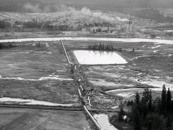
For one thing, no signs tell you that you are at the Somass Estuary. Mostly they say things like “No trespassing” and “Do not park in front of the gate” and, lately, “Do not enter construction zone.” The parking area at the Old Airport Road attracts garbage—some of it putrid fish. The other has a rough parking area across the road from the “entrance” to the pipeline. At one time MacMillan Bloedel owned all of it except for the city sewage lagoon and the road into it. Now, the properties that comprise what is left of the natural area of the estuary are owned by the Tseshaht First Nation, Ducks Unlimited, Paper Excellence Canada (formerly Catalyst Paper) and Island Timberlands. What a mish-mash. Oh, and the port authority has some jurisdiction over it too.
So how come the public is allowed in on foot? I mean all the other sewage lagoons I’ve ever come across have had locked fences around them. I think it’s because it’s always been like that. We are privileged to have the situation. Fortunately, there have not been enough incidents that require higher security.
The other access is just past the Tseshaht Reserve. Where the paved road bends to the right away from the river, a paved road continues along it. Two hundred metres along the road is a gate with a small clearing big enough for a couple of vehicles, while a couple more could park along the road. There is no sign on the gate. No indication that the public is or isn’t allowed. In fact, it is owned by the Tseshaht First Nation. But there is an easement along the road. So if you stay on the road until you are past the poplar plantation, you will not be trespassing. But how is one to know this when facing the gate for the first time? You find out by word of mouth.
When you get to the Ducks Unlimited property, you encounter a big hayfield with a big old gnarled Douglas Fir tree at the edge and a marsh beyond. In the background, a forested edge lines the river and a big white pipeline traverses the estuary on its way to the paper mill. The mill and town are barely visible as the hills and mountains that line the valley dominate the scene. Finally, there are two signs announcing the property.
One is a memorial for Günter Paetzold and his wife, donors to Ducks Unlimited, and the other announces that you are at the awkwardly-named Somass Estuary Management Area.
There are a few rules as well: no off-leash dogs, no motorized vehicles, no garbage and respect the hayfield. (I think that means, don’t walk all over it). There is more DU property on the other side that includes what’s known as Johnston Island, a forested island surrounded by marsh, and the new city sewage lagoon currently under construction.
This property is the last part of the estuary that has not been impacted by modern newcomers. This fact has been recognized by governments and land owners, and local clubs and associations in a management plan that is available to the public on the regional district’s website. The plan was created in 2004 with a provision for a recreation trail and viewing platforms through the five properties. From the entrance to the DU property, the trail heads south straight toward the pipeline and the access road. This section of the trail doesn’t formally exist yet. Currently it is little more than a bear track.
There is a third entrance where the paper mill’s pipeline emerges from underground by the paved access road and crosses the estuary. It provides access along a boardwalk on either side of the pipeline. There are “No Trespassing” signs on it; but it is walked by many members of the public as it provides a higher vantage point for observing wildlife in the area. I have never heard of anyone being told to get off it. So it also is included in the ambiguity of public access to the area.
From a biological, cultural, historic and social perspective, this area is a landmark and an attraction. It could be an economic attraction, too, if the issue of public access was a little clearer. More visitors might come to visit it as a tourist attraction.